The Impossible Maps of Antarctica
The very strange maps that showed the South American continent in the 16th century also bore precise depictions of Antarctica not covered by ice. What was the source?

Charles Hapgood is one of the most important scientific figures of recent times. Unfortunately, he was not strictly a scientist: he was a university professor who graduated in medieval and modern history from Harvard University in 1932. He became famous at the end of the 20th century because he was considered the promoter of the Theory of Earth's Magnetic Pole Shift: a simple yet revolutionary theory capable of explaining, like no other before it, the Myth of Myths.
It all began when Hapgood, prompted by a student's question about the mystery of the disappearance of the mythical continents of Mu and Atlantis, decided to investigate the matter without prejudice.
In 1958, he published his first book "The Earth's Shifting Crust." In the book, Hapgood formulated a theory in which he stated that the Earth's axis had shifted numerous times throughout the planet's geological history. The thesis was innovative and intelligent, but although the "Pole Shifting" theory was accepted by some official geologists, it received numerous criticisms, often heavy and nonsensical as we will see later.
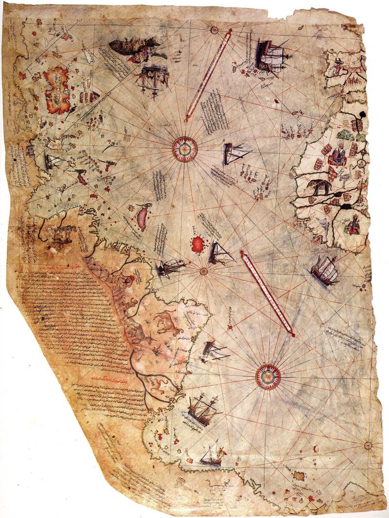

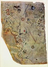
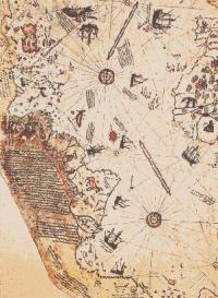
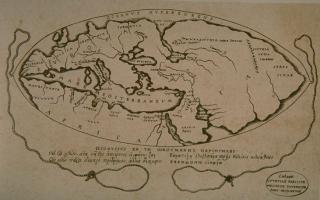
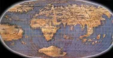
To write his book, Hapgood used numerous ancient maps, including the famous one by Piri Reis, a 16th-century Ottoman admiral. The source of this map was provided by Christopher Columbus: its peculiarity is that it shows an extensive continent very similar in shape to Antarctica. The map was drawn in 1513, based on information from pre-existing texts.
Surprisingly, it depicted part of the Antarctic continent free of ice and connected to the southern tip of Cape Horn, at the edge of Argentina.


This seems odd since officially, history tells us that the Eighth Continent was only discovered in 1818; for this reason, geologists worldwide have attacked Hapgood's theory. According to them, it is absurd that "impossible" maps depict Antarctica when its existence was unknown before then. In fact, one of the most absurd interpretations from geologists attacking Hapgood is that the drawings show a completely imaginary and invented territory by the cartographers of the time, solely to "balance the maps," as the continents were only present in the northern part of the world, so the resemblance to Antarctica is "purely coincidental." Nonetheless, the fact remains that it was present on all the old maps (and quite accurately too!).
On one of these geographic representations, the eastern coast of South America is detailed, showing it close to the Antarctic coasts, very similar to the current layout. This resemblance is even more significant when considering that the sea level during the last glaciation was 130 meters lower, making the lands significantly closer. Therefore, if these maps predate the discovery of the American continent, it is evident that those who possessed them, in this case specifically Christopher Columbus, received them from someone who was knowledgeable about the profiles of the Antarctic and South American lands during the last glaciation.
Moreover, the fact that these drawings also depict the Falkland Islands (discovered in 1592) suggests that these maps must be dated much earlier since the existence of that archipelago was unknown at the time.
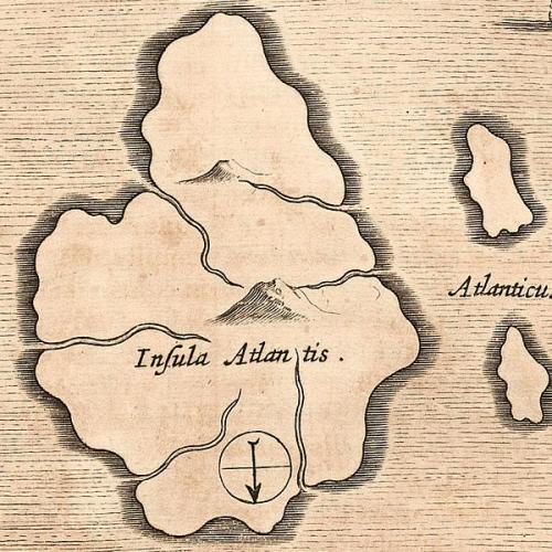
In this context, all references point to the lost civilization par excellence, Atlantis. Hapgood sought to find scientific evidence of the cataclysms of ancient times in these documents to prove the ancient stories of this lost continent, and it seems that the maps speak clearly.


According to the scientist's theory, in very ancient times, the geographical poles were positioned differently; that is, the Earth's axis was tilted by about 15 degrees. Consequently, the North Pole was located 3,000 km further south than today, while the South Pole was shifted the same distance but further north. This accounts for the accuracy of the maps, which show Antarctica much further north, with much of its lands free of ice and having a milder climate. Meanwhile, much of the northern glaciers covered lands up to the northern United States and all the Arctic Europe up to the British Isles.
According to Hapgood, this explains the existence of the continent of Atlantis, placing it in the middle of the Atlantic Ocean, just as Plato described, but positioned higher, between Europe and North America. His theory also involves the shifting of the magnetic poles, which, according to him, would have reversed, causing cataclysms and climatic upheavals, the same ones that caused the disappearance of Atlantis, as all ancient civilizations recount in the myth of the Great Flood.
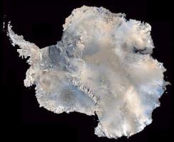
This theory was also confirmed by a famous Italian scientist, Flavio Barbiero, who discovered traces of an ancient petrified forest in Antarctica, specifically in King George's Land, in December 1974, dating back at least 10-12 thousand years. Thus, the heavy criticisms from traditionalist scientists, who claim that Antarctica has never been populated in the past because they believe it has been covered by ice for 300 million years and that no one knew of this continent's existence until 1818, are entirely unfounded.


Only a few scholars have given credence to this hypothesis, one of them being the famous Graham Hancock. In his book "Fingerprints of the Gods," he used this theory to assert the existence of an ancient, technologically advanced civilization that existed in remote times and then disappeared during a great cataclysm following a shift in the Earth's axis. According to Hancock, these maps could have been drawn around 10,000 BCE. Furthermore, the maps show the different morphology of the Azores, depicted as a single large island off the coast of Portugal, or other small islands not present on current maps; this can be explained, as mentioned earlier, by the much lower sea level at that time, which rose following a massive flood.


Everything fits: the Great Flood narrated by all the peoples of the Earth, the 3,000 km shift of the Earth's axis, and the melting of the ice caps wiped out all coastal human cities that were below 130 meters in elevation (as we discuss extensively in this article). Perhaps what remained were only the maps of that world, which the planet-wide cataclysm had upended. These maps were housed in the Library of Alexandria in Egypt, which, before being destroyed, was set on fire three times. Without a doubt, as the Egyptian custodians of the Hellenistic era specified, it contained documents from a time before the Flood.
But in this fascinating and entirely logical story, one question arises spontaneously. Who gave the map (which ended up in the hands of Piri Reis) to Christopher Columbus? And more importantly, were the Americas already drawn on it before he went there?